
The gvSIG Association, beyond being known for the development of various technologies in open source software like gvSIG Desktop or gvNIX, it has become in recent years to an international reference in the provision of open source geomatics and specially what refers to the implementation of Spatial Data Infrastructures (SDI) with open source Software.
Focused on the SDI, in this post we want to talk you about one of the last developed project: the implementation of one SDI in the International Union for Conservation of Nature (IUCN). This project is the new product of the gvSIG Association, gvSIG Online, of which we will talk about in future posts.
IUCN is the world’s oldest and largest global environmental organisation, with almost 1,300 government and NGO Members and more than 15,000 volunteer experts in 185 countries. Their work is supported by almost 1,000 staff in 45 offices and hundreds of partners in public, NGO and private sectors around the world.
In practice, this means thousand of field projects and activities around the world…many of them with a geographic component and producing georeferenced information. A really valued information which, until this project, it was almost impossible to reuse it, because there was not a mechanism for having it located, share it, combine it or interact with, for exploiting all the potential of this database of spatial knowledge.
The SDI project was proposed as a project for solving a concrete problematic and being able to go over all the organization.Thus, in the Mesoamerica office was proposed its application to the projects of restoration of rural landscapes as the first point of the SDI.
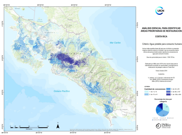
The restoration projects of rural landscapes based on a set of techniques and activities to strengthen the resilience of landscapes under the methodology known as ROAM (Restoration Opportunities Assessment Methodology) , are an exemplary case of project where geographic information constitutes a fundamental source of information . In this case the countries involved are: Costa Rica, El Salvador, Guatemala, Mexico and Nicaragua.
The following diagram shows clearly that the conclusions of each of these phases are …geographic information:
Without going into details, in the three stages of the ROAM we find:
- First stage: is required to have various geographic data that are the basis for further analysis (water maps, permeability water, irrigation, …-, biodiversity, energy, soils, etc.).
- Second stage: need to compare the map with the current use with the one of restored use, which will analyze the restore options.
- Third stage: map of priority areas to restore.
The conclusions of each one of these sentences are a map, geographical information.

The implemented SDI, based on the suite of gvSIG Online, has some components such as the (PostGIS) database, (Geoserver) map server, tiling service and cache (WMTS), GIS desktop client (gvSIG Desktop), etc. Also, the implementation of a public/private geoportal with powerful and easy management tools, which gives the maximum potential to the users and allow easily to upload new layers, change legends, labels, etc.
Of course, the project has included all the training tasks and technological transfer giving the maximum guarantees to the client. This is only possible when we work with open source technologies.
And this is only the start of one project which has started to expand over all the organization.
The link for the public geoportal of the project can be found at:
https://ideormacc.org/gvsigonline/
And if you want to know more about the project you can check in the conference video of one of the sessions at the International gvSIG Conference:
If you are interested in implementing this kind of projects in your organization, contact us: info@gvsig.com . In addition to have the best experts in open source geomatics, you will be helping to the maintenance and development of the gvSIG technology.


Pingback: gvSIG Online: SDI for the International Union for Conservation of Nature (IUCN) – GeoNe.ws