How to download and compile gvSIG 2.1.0 on Linux and Windows

English translation of the article by Joaquin del Cerro.

Note: I shall describe how to compile gvSIG Desktop core. This is only part of a broader process of distributing gvSIG. Other add-ons are compiled separately.

Hello all,

Typically, I develop on Linux, Ubuntu or Kubuntu. Download and compile gvSIG core for Ubuntu is often easy.

This can be done by executing a few simple commands which are easy to install because they are in the application packages repository and they can be installed using the “apt-get” command. You will need to have installed:

  • JDK 1.7, I often use “openjdk-7-jdk”
  • Subversion client, usually “subversion”
  • Maven, it is necessary to install “maven” package.

Execute it from command console

sudo apt-get install openjdk-7-jdk subversion maven

Once we have that, to download, compile and execute gvSIG proceed as follows:

~ $ cd
~ $ mkdir -p devel/gvsig-desktop
~ $ cd devel/gvsig-desktop
~ $ svn checkout https://devel.gvsig.org/svn/gvsig-desktop/trunk/org.gvsig.desktop/
...output for svn command...
~ $ cd org.gvsig.desktop
~ $ mvn install
... output for install command...
~ $ cd target/product
~ $ ./gvSIG.sh

Without having the tools to develop on Ms Windows, matters are slightly unstuck.

I’m going to tell you quickly what we should install to develop on MS Windows what we have already explained for Linux.

While is obviously necessary to have JDK, Subversion and Maven JDK, as we have in Linux, I would also recommend a couple of utilities more.  What I miss most in Windows is a console with more capabilities. I would like most of all it would be resizable and I could configure the field history. After some research on the web, in the end I have opted for Console2. The project is hosted on SourceForge, and we can download the binary files from:

Next thing we will need is to have an environment for running Linux style shell files (bash). Among all of the environments available for MS Windows, I have chosen Busybox, because it combines compile and execute gvSIG into a single executable so system memory is not overflow. Download the binary files from:

This is just an executable, no additional installation is required. I have placed it in Windows folder, in my system only as a convenience.

C:\WINDOWS

Once we have downloaded both utilities, install Console2.Default values are generally appropriate. Only some modifications:

  • Increase Screen Buffer Size. Go to menu “Edit->Settings…” and we can change it in “Console” section. I usually have 2000.
  • Configure a new “tab”. In the same menu as before (Edit->Settings), go to “Tabs” section and configure a new tab with the following values:
  • Title “Terminal (busybox)”
  • Icon Use default
  • Shell “busybox bash -l”
  • Startup dir “C:\”

I leave it as the first “Tab” on the list and, in that way,   it is initiated by default when we start up Console2

Actually, if I start Console2  from the desktop icon I can already run “Linux” style shell scripts.

Now, install the following components:

  • JDK 1.7, available  for download at the Oracle website.

http://sourceforge.net/projects/win32svn/files/latest/download

I have installed it on the folder “C:/Program files”.

  • Maven, I downloaded it from a mirror on its official website:

http://apache.rediris.es/maven/maven-3/3.1.1/binaries/apache-maven-3.1.1-bin.zip

Once it has downloaded, I extracted it in the folder:

C:/Program files/apache-maven-3.0.5

Once everything is installed, it needs only same configurations. In the user HOME the “.profile” file must be created, in my case in:

C:/Documents and Settings/devel/.profile

A quick way to locate our HOME could be boot Console2  and in the shell we have just configured, run:

~ $ cd
~ $ pwd
C:/Documents and Settings/devel
~ $

And it will locate our HOME.

There we will create the “.profile” file with the following content:

#---------------------------
# .profile 
export JAVA_HOME="C:/Progam files/Java/jdk1.7.0_71"
PATH="$PATH;C:/Program files/Java/jdk1.7.0_71/bin"
PATH="$PATH;C:/Program files/Subversion/bin"
PATH="$PATH;C:/Program filse/apache-maven-3.0.5/bin"
alias l="ls -l "
alias ll="ls -l "
# 
#---------------------------

Basically, we create the JAVA_HOME variable and we add the folders with the JDK, Subversion and Maven binary files to the PATH. Routes can changed depending on where you have installed the tools

Once created the file, we close the console and will reopen it to assure that console reads the file. We are ready to download, execute and compile gvSIG.

To do this, we run the same commands from our Console2 as I said before for Linux. Well, we will make a small change….download the fonts to “C:\devel”. This is to avoid problems with the length of file. Many windows programs, including “Explorer” or “cmd”, have problems to access files whose names are larger than 255 characters and at the end, there are usually quite   long file name in the gvSIG file structure.

~ $ cd c:/
~ $ mkdir devel
~ $ cd devel
~ $ svn checkout https://devel.gvsig.org/svn/gvsig-desktop/trunk/org.gvsig.desktop/
...output for svn command...
~ $ cd org.gvsig.desktop
~ $ mvn install
...output for install command...
~ $ cd target/product
~ $ ./gvSIG.sh

Just to make sure to reproduce this steps (links can change), I put on the link:

http://devel.gvsig.org/download/tools/gvsig-desktop/2.1.0

A copy of download files of:

In that way, everybody can have the same program version as me.

I had left out…

I hope comment it, albeit briefly, in next articles.

Regards,

Joaquín
Posted in development, english, gvSIG Desktop | Comments Off on How to download and compile gvSIG 2.1.0 on Linux and Windows

gvSIG 2.1: Biblioteca de símbolos para el transporte (AIGA)

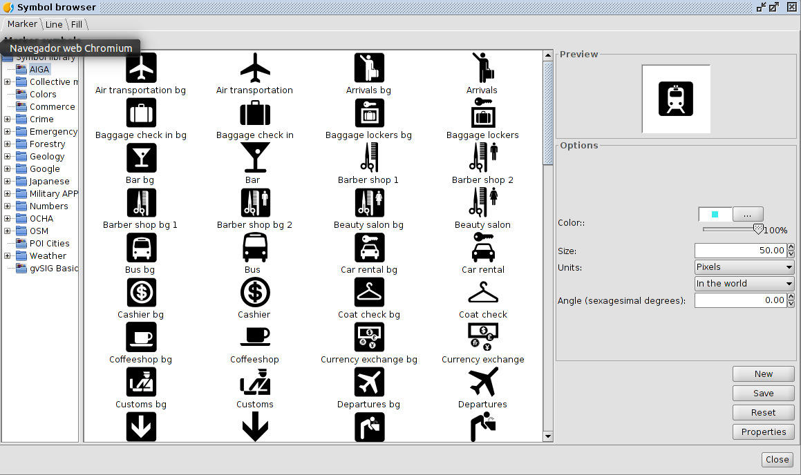
En gvSIG 2.1 podemos instalar, entre las bibliotecas de símbolos disponibles, la denominada AIGA.  AIGA es el acronimo del American Institute of Graphic Arts.
AIGA es conocida por sus actividades de diseño técnico, específicamente en la creación de pictogramas del Departamento de Transporte de los Estados Unidos en 1979. Precisamente, basándonos en ese conjunto de pictogramas, hemos generado una nueva biblioteca de símbolos.
Los símbolos puntuales los hemos complementado con un conjunto de símbolos para líneas y rellenos inspirados en la paleta de color utilizada en el documento “Thinking inside the box. AIGA identity and branding guidelines“.
Para instalarlo, como es habitual, debemos utilizar el administrador de complementos de gvSIG.

Una vez instalado podremos utilizar símbolos como estos:

AIGA_gvSIG

Posted in gvSIG Desktop, opinion, spanish | Tagged , , | 3 Comments

I Cátedra gvSIG Contest. Works with free GIS

The aim of the Cátedra gvSIG is to create a meeting point for users interested in free space technologies. In order to foment an environment of shared knowledge and participating in the dissemination of free geomatics, the chair organizes this international contest to encourage all gvSIG users and free Geographic Information Systems users to share and give visibility to their work.

Students and graduates in high school, professional training and university, as well as university professors and researchers from all countries can participate in this contest.

To enter to the competition you must meet the following requirements: Works must be done with free Geographic Information Systems and the subject of the work may address any area of knowledge.

Works may have been made in 2015 or before, the papers may be presented collectively and individually and jobs may be sent in Spanish, Valencian or English.

In the event the work is based on a new development done through free and open source GIS geospatial technologies, these papers must be subjected to GNU / GPL v3 license.

Among the selected works a prize of 500 euros will be awarded for each of the following categories:

  1. Work produced by students of highschool or professional training
  2. Final University’s Project (Bachelor, Degree or Master)
  3. Doctoral thesis or research paper.

Submissions should be sent to gvsig@umh.es no later than November 1, 2015.

Selected documents will be published in the repository of the Miguel Hernández University.

The jury will evaluate the methodology, clarity and innovative nature of the work, assessing as well the relevance and applicability of the research. Winners will be announced in the next International gvSIG Conference.

For more information visit the contest page of the Chair (in Spanish) or contact gvSIG gvsig@umh.es via email.

Posted in community, english, gvSIG Desktop, gvSIG Educa, gvSIG Mobile | 1 Comment

gvSIG applied to Architecture

The 10th International gvSIG Conference were held some weeks ago in Valencia (Spain), where more than thirty communications were presented about different themes.

At the Conference there was a session specially dedicated to architecture. Different reports were presented about Geographic Information Systems in an architecture office, urban licenses or energy efficiency certificates, all of them very interesting projects.

All these presentations, as well as their recording, are available. They were concretely these ones:

– GIS applied to project management in an architecture office (PDF: 8.0 MB); VICENTE J. VALERO (Grado en Arquitectura Técnica)

– Geographic Information Systems for urban licenses management (PDF: 4.7 MB); PABLO PERUCHO (Grado en Arquitectura Técnica)

– GIS applied to energy efficiency certificates in the municipality of Llíria (PDF: 5.4 MB); MIGUEL ÁNGEL SIMEÓ (Grado en Arquitectura Técnica)

– Multicriterial metodology for the optimal location searching of a public site (ODP: 10.7 MB; PDF: 4.1 MB); RUBÉN HERNÁNDEZ (Grado en Arquitectura Técnica)

– Questions at this sessions:

We hope this information is useful for you!


Posted in english, events, gvSIG Desktop | 13 Comments

gvSIG 2.1: Symbol library for collective mapping

“Territory is the socially built space”, with this sentence starts the excellent “Collective mapping tutorial. Critical mapping resources for shared mapping ” in Spanish, by Iconoclasistas (there’s another tutorial in English, with license CC BY-SA 2.0 – Creative Commons, called Collective mapping).

In this tutorial, with licence Attribution Non-commercial Share Alike 2.5, we find a symbology orientated to be used at the collective mapping workshops. Symbology which is not the usual representation of geographical elements to add an iconography for ideological representations.

And although originally the symbology was created to be used in a more crafty way in the different workshops, we think that is really interesting to have it in a opensource GIS and that gvSIG could be a tool to do this type of collective mapping jobs and the analysis of our social reality.

For all these reasons, we want to add to the comunity the new add-on for gvSIG 2.1, which is just a symbol library for collective mapping.

We hope that you like it.

Here is a video showing how to install this library (as usual, from add-ons administrator):

Posted in gvSIG Desktop, spanish | Tagged , , | 2 Comments

Concurso Cátedra gvSIG de trabajos con Sistemas de Información Geográfica libres

La Cátedra gvSIG comienza sus actividades con la intención de crear un punto de encuentro para los usuarios interesados en las tecnologías espaciales libres. Con el objetivo de crear un entorno de conocimiento compartido y de participar en la difusión de la geomática libre, la cátedra convoca este concurso internacional para animar a todos los usuarios de gvSIG y Sistemas de Información Geográfica libres a compartir y dar visibilidad a sus trabajos.

Pueden participar en este concurso estudiantes y graduados de Bachillerato y Formación Profesional, estudiantes y graduados universitarios, así como profesores universitarios e investigadores de todos los países.

Los trabajos pueden tratar sobre cualquier área de conocimiento, con el requisito de haber sido realizados con Sistemas de Información Geográfica libres. En el caso de que el trabajo se base en un nuevo desarrollo realizado a través de tecnologías geoespaciales libres y SIG libres, estos desarrollos estarán sujetos a una licencia GNU/GPL v3. Los trabajos pueden haber sido realizados en 2015 o con anterioridad, los concursantes podrán presentarse de forma colectiva e individual y su trabajo podrá enviarse en castellano, valenciano o inglés.

Entre los trabajos seleccionados se otorgará un premio de 500 euros para cada una de las siguientes categorías:

  1. Trabajo elaborado por alumnos de Bachillerato o Formación Profesional
  2. Proyecto Fin de Titulación Universitaria (Licenciatura, Grado, Máster)
  3. Tesis doctoral o trabajo de investigación.

Los trabajos deberán enviarse antes del 1 de noviembre de 2015 a la dirección de correo electrónico gvsig@umh.es.

Los trabajos seleccionados se compartirán en el repositorio de la Universidad Miguel Hernández. El jurado evaluará la metodología, la claridad y el carácter innovador de los trabajos, valorando también la pertinencia y aplicabilidad en el caso de trabajos de investigación. Los ganadores serán anunciados en las próximas Jornadas Internacionales gvSIG [1].

Para más información consulta las bases del concurso en la página de la Cátedra gvSIG [2] o contacta a través del correo electrónico gvsig@umh.es.

[1] http://jornadas.gvsig.org
[2] http://gvsig.edu.umh.es

Posted in community, events, gvSIG Desktop, gvSIG Educa, gvSIG Mobile, spanish | 1 Comment

Advanced labelling in gvSIG 2.1

One of the features that can be found in gvSIG 2.1 is advanced labelling, that includes many possibilities and tools to customize label according to user need. The advanced labeling has been migrated from gvSIG 1.x to gvSIG 2.1, keeping all the existing customization options and adding some of the most required options by the user community, like the halo option.

Here are a couple of videos that show some ( of the many ) labelling options .

In this first video we focus on the possibility of labelling with halo or adding a background image for tags.

In the second video we illustrate the possibility to display labels only for selected features.

English translation of Etiquetado avanzado en gvSIG 2.1.

Posted in english, gvSIG Desktop | Tagged , , , | 2 Comments

Etiquetado avanzado en gvSIG 2.1

Otra de las funcionalidades que podemos encontrar en gvSIG 2.1 es la de etiquetado avanzado, que a su vez contiene distintas posibilidades y herramientas para confeccionar un etiquetado al gusto del usuario. El etiquetado avanzado ha sido migrado de gvSIG 1.x a gvSIG 2.1, manteniendo todas las opciones de personalización del etiquetado e incorporando al mismo tiempo alguna novedad de las más solicitadas por la comunidad de usuarios, como es la opción de halo.

A continuación un par de vídeos que muestran algunas (de las muchas) opciones de etiquetado.

En este primer vídeo nos centramos en la posibilidad de etiquetar con halo o añadiendo alguna imagen de fondo que acompañe a las etiquetas.

En el segundo vídeo vemos la posibilidad de que las etiquetas se muestren sólo cuando seleccionemos un elemento.

Posted in gvSIG Desktop, spanish | Tagged , , , | 3 Comments

Exercises of the Scripting Workshop at the 10th International gvSIG Conference

Hi there,

In this post, you will find the examples made in the workshop for beginners about Programming with Scripting Module in gvSIG 2.1 at the 10th International gvSIG Conference in December at Valencia.

During the workshop, we saw a few examples of geoprocessing, starting with the calculation of a buffer area and little by little, adding functionalities according to our needs.

Here the cartography to follow the scripts.We only need a polygone layer and a point layer. You can use your own layers if you want.S

If you don´t know the Scripting Module, we explain how to load the scripts, step by step, at this video. In the code, you only should change the part as ‘initial data’, writing the path where the new lawyer will be recorded. These scripts will not modify the layers already loaded. For the correct running, we should have the View on and one layer selected.

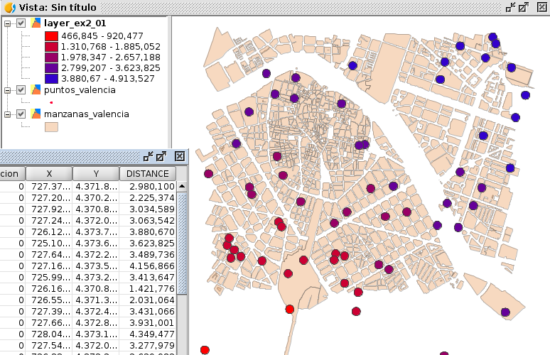
In the first two examples, we can see first, the creation of a buffer area and secondly, adding a new field showing the distance between those points to a reference point.

Script 1: Buffer

Script 2: Buffer and new field with spatial information

taller_scripting_ejer_02

Script 2

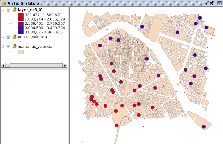
Also, in the third example, we add a spatial condition. This condition is just that it creates the buffer in those points intersecting with some polygon from the selected layer. In the example, referred to ‘manzanas’, but it can be replaced for any polygon layer. We can see in the symbology how this variable evolves, thinking that the reference point from the example it would be at the left bottom side. We also see that there are points where the buffer has not been generated.

Script 3: Buffer, distance new field and complying the intersection.

taller_scripting_ejer_03

Script 3

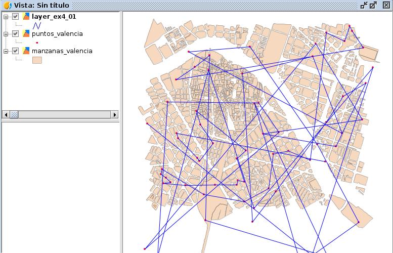
Another function is, from a point layer, to create a new line layer containing (in this case, a single entity to help us) a geometry with the union of all the points with all the vertices of the line.

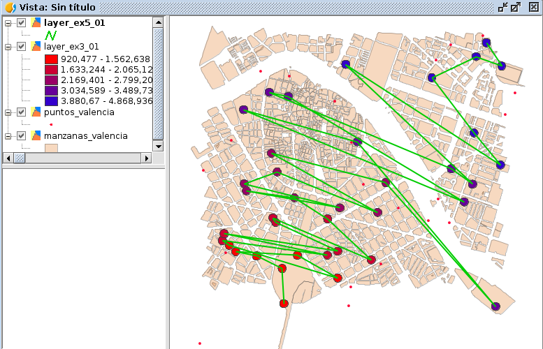
In the first example, passing the vertices using the order of an ID field which would be random, and in the second one, using the buffer layer created in the 3rd script and taking as an order, the distance field to create the vertices of the line geometry.

Script 4: Convert points to line

taller_scripting_ejer_04

Script 4


Script 5: Convert buffer layer line

taller_scripting_ejer_05

Script 5

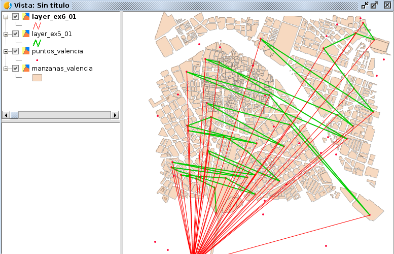
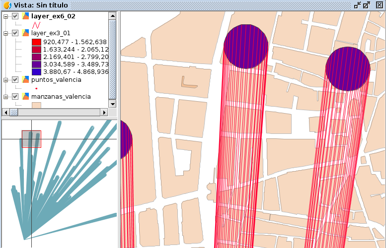
Finally, an example not explained during the workshop is the generation of lines projecting to that reference point, taking into account the type of layer: points, lines or polygons.

Script 6: Projected lines

Script 6: Initial line layer

Capa inicial de polígonos

Script 6:Initial polygon layer

You can watch the workshop videos on the following links (Spanish/English):

  • Spanish: 10as Jornadas Internacionales gvSIG: Taller 5, Scripting en gvSIG 2.1:

https://www.youtube.com/watch?v=DFRUZh0CzbI

  • English: 10th Int. gvSIG Conference: Workshop 5, Scripting on gvSIG 2.1:

https://www.youtube.com/watch?v=fKkclGGTHKs

Any doubt, you can ask here, at gvSIG user list or if it is a more specific one, you can contact me: omartinez@gvsig.com

If you are interested in the rest of the presentations of the Conference, you can check them out at this listing.

I hope these examples were useful.

Greetings to all and thank you,

Óscar

Posted in development, english, events, gvSIG Desktop, scripting | 1 Comment

gvSIG aplicado a Arquitectura

Hace unas semanas se celebraron las 10as Jornadas Internacionales gvSIG en Valencia (España), en las que se presentaron una gran cantidad de ponencias de temáticas distintas. En ellas hubo una sesión dedicada especialmente a arquitectura, en la que se presentaron varias ponencias con temas distintos como Sistemas de Información Geográfica en un despacho de arquitectura, licencias urbanísticas, o certificados de eficiencia energética, todos ellos proyectos muy interesantes.

Están disponibles tanto las presentaciones como la grabación de las mismas. Las ponencias que se presentaron relativas a arquitectura fueron concretamente:

– Los SIG aplicados a la gestión de proyectos en un despacho de arquitectura (PDF: 8.0 MB); VICENTE J. VALERO (Grado en Arquitectura Técnica)

– Sistemas de Información Geográfica para el Control de Licencias Urbanísticas (PDF: 4.7 MB); PABLO PERUCHO (Grado en Arquitectura Técnica)

– Aplicación de los SIG a los certificados de eficiencia energética en la localidad de Llíria (PDF: 5.4 MB); MIGUEL ÁNGEL SIMEÓ (Grado en Arquitectura Técnica)

– Metodología Multicriterio Para La Búsqueda De La Ubicación Óptima De Un Emplazamiento Público (ODP: 10.7 MB; PDF: 4.1 MB); RUBÉN HERNÁNDEZ (Grado en Arquitectura Técnica)

– Ruegos y preguntas de dicha sesión:

¡Esperamos que os sea útil esta información!


Posted in events, gvSIG Desktop, spanish | 4 Comments