
This extension will become an indispensable tool for users who need to publish their maps using MapServer, MapProxy and TinyOWS.
Its aim is to enable a process automation for the maps publishing services , trying to obtain results as true as possible to the original work made in our gvSIG 2.1
The extension can be found with the name ‘org.gvsig.publish‘, and it can be installed from the ‘Plugin Manager’, selecting the URL installation and in the drop-down of (Testing gvSIG repository – http://downloads.gvsig.org/download/gvsig-desktop-testing/).
Once installed, we will have access to the publishing functionality either through the menu View>Export>Export view to mapfile, either via the button appropriate.
Let´s see with a quick guide, how this extension works:
Selection of the local work directory
In order to operate more comfortably, this extension requires that you define a local folder on your computer to store and create the whole project structure.
It can be a new directory (created if doesn´t exist), empty or one which already has previously worked (to join several works in one only project).
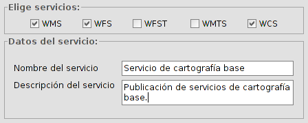
Advanced options: Services selection
If we check the ‘Advanced options’, we will be able to access to the available services through the ‘Service’ tab, in which we can mark as many as we need, performing the publishing once.
Each service will create a subfolder with its name in the project directory and inside of the subfolder, all the files needed for that concrete service will be stored.
Also, we have offered the possibility to indicate the name under which the service will be displayed to customers and the description in the same form.
Project creation
If the final directory where the project is going to be stored is not empty, the app will ask us to choose between overwrite, add or cancel.
-
Overwrite: It will create all the files needed for the project, being able to change the previous files content if it is required.
-
Add: if we want to add more information to a project without losing any previous information.
In following posts, we will carry on with more possibilities of this new plugin, such as the manual edition of specific attributes and the upload of the project to the server. There are, as well, good possibilities with its combination with other plugin (which we hope to release soon) allowing to generate legends and label by scales.


Pingback: Publishing extension: manual edition of specifics attributes | gvSIG blog
Pingback: On the road to gvSIG 2.2: Publishing extension | Geo-How-To News
Pingback: Publishing extension: Project upload to the server | gvSIG blog
Pingback: New extension: Create legends by scale | gvSIG blog
Pingback: gvSIG 2.2 available! | gvSIG blog