
Now we are going to see a very easy and useful tool. It allows to add X and Y coordinates (or Latitude/Longitude) to a point layer in an automatic way. In our case, with fictitious cartography on EPSG 4326 projection system (the system used by GPS), we will get the coordinates that represent latitude and longitude.
We have “Locations” point layer, and we are going to check the “Add X and Y” tool.
Firstly we are going to put “Locations” layer active, and we open its attribute table (as we saw in the “Tables” post).
Then we run the tool, from the “Table/Add measure/Add X and Y”, or from its corresponding button:
We will see that two new columns will be added to the attribute table, with the information of the coordinates.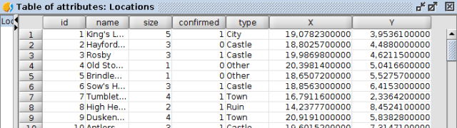
And now we can send our dragons to the exact coordinates…
See you in the next post…


