
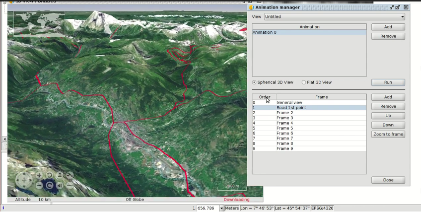
The video of the fifteenth module is now available, in which we will see the main functionalities of the 3D extension in gvSIG, based on NASA WorldWind application.
In this module the user will learn how to create a 3D View from a 2D one. The 3D Views that we can create are flat views, when we work in local areas, and spherical views, when we want to see them on the terrestrial sphere.
In the 3D Views we can visualize the digital elevation models, and we can overlap any other layer on them, such as an orthophoto.
On the other hand, if we have a vector layer with building footprints, and a field in which we have the number of floors or the height of the building, we can apply extrusion, so that we can see the polygons vertically as if it were the building, and it helps us to visualize the structure of the city in an easy way.





 Alvaro
 Amparo Cisneros
 adelrey
 Alegria
 asoredesocial2006
 Augusta
 christinesig
 cordin
 csanper
 danielvicb
 dispiste
 edmarmoretti
 elenasanchez232
 eliazerk
 fjsolis
 Gabi
Gabi ggowtham
 Giuliano Ramat
 Valenty
 Georg Sedlmeir
 hydrologiclady
 jgalans
 Joaquin del Cerro
 Juan Lucas Domínguez Rubio
 jolicar
 josebadia
 Jorge Piera Llodrá
 Jordi Torres
 Chevi
Chevi learozz
 leoruizb
 Alonso Morilla
 Lluís Marqués
 martapacoret
 Óscar Martínez
 mateoboudon
 mateocb16000
 Mario
Mario Mario Chaveli
 mjlobato76
 Manuel
 mmontesinos
 moovida
 Nacho Varela
 nbrodin
 André
André piotrpachol
 psanxiao
 Sergio Acosta y Lara
 Spatioblog
 Sergio Acosta y Lara
 uliwerz
 Victor Acevedo
 Viqui
Viqui volaya

 gvSIG blog