
A new module of the free GIS course applied to Archeology is now available. With this module we are already starting to explore some of the advanced tools of Geographic Information Systems.
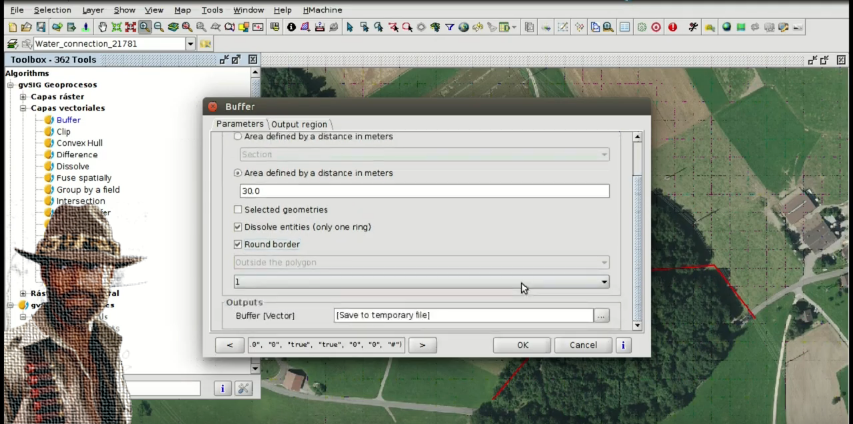
We will see how to apply vector geoprocesses to analyze the geographic information related to an archaeological site. We will also work with the information obtained from a GPS in a GPX file.
If you have not done the previous exercises, we recommend you to start with the first module.
We remind you that the data to follow the course can be downloaded in a compressed .zip file from this link.
Remember that for doubts about software use, carrying out the exercises, and problems that you find when carrying out the course, you can use the gvSIG users mailing list.
Module 3. Analysis of prospection results
Previous modules:
Module 1: Preparation of an archaeological project
Module 2: Digitalizing prospection areas. GIS applied to Archeology


Oh great! As a student of archaeology I will definitely go for it.
I have downloaded the data, installed software but the software doesn’t work.
Sent from Yahoo Mail on Android
Hi Chinyere, could you send the problem to the mailing list? At this post you can see how to do it: https://blog.gvsig.org/2015/06/17/what-to-do-when-we-get-an-error-in-gvsig/
Pingback: Working with historical maps: Georeferencing images. GIS applied to archaeology | gvSIG blog
Pingback: Territorial analysis of archaeological sites: Raster geoprocessing and Digital Elevation Models. GIS applied to Archeology | gvSIG blog
I want to reading this course his
I need to apply &admission
Hi Aliyu, the course is free and any registration is required. You only have to follow the videos that will are publishing at this blog. At this post you have the last module that we have published, and at the end of the post you can see the links to the first ones.
Pingback: Hydrological analysis to locate archaeological material or sites. GIS applied to Archeology | gvSIG blog
Pingback: Graphical output of an archaeological project: Layouts. GIS applied to Archeology | gvSIG blog
Pingback: Free course about Geographic Information Systems applied to archaeology: Certification and links to the complete course | gvSIG blog