gvSIG, an important tool applied to Open Education

poster_gvSIG_open_education

In the light of the International Map Year (IMY), the ICA and its commissions are highlighting the value of cartography by “mapping” the UN sustainable development goals.

The sustainable development goals and their targets can be mapped based on the indicators. ICA’s Commissions have mapped each of the goals from their particular perspective. The resulting poster collection gives an overview of the strength of cartography. It is telling the story of cartographic diversity, of mapping options and of multiple map perspectives.

Poster made by the Commission on Open Source Geospatial Technologies is about the Goal 10 (Reduced inequalities) and gvSIG appears as an important tool applied to educational environments.

Poster:

http://icaci.org/files/developmentgoals/goal_10.pdf

Posted in english, events, gvSIG Desktop, gvSIG Educa | Tagged , , , , , , , , | Leave a comment

Mapping dedica de nuevo un número especial al proyecto gvSIG

mapping_gvsig

La revista Mapping, un referente en las publicaciones relacionadas con las ciencias de la tierra, dedica su número 177, de mayo-junio de 2016, al proyecto gvSIG.

El conocimiento de hoy es la base del mañana” con esta frase de relación directa con los valores del software libre, comienza el especial con artículos de trabajos presentados en las pasadas Jornadas Internacionales de gvSIG. Valga citar unos ejemplos para atisbar la variedad temática en la que se aplica la tecnología gvSIG y que viene reflejada en forma de artículos como:

  • Reconstrucción de los sistemas de la Compañía Inglesa de Aguas para el abastecimiento a Cartagena, del siglo XIX hasta mediados del XX.
  • Arqueometría y georreferenciación con gvSIG en un yacimiento al aire libre. Campaña Mas d’Is 2015.
  • Las Cuevas-Santuario de la costa oriental de Yucatán: Un paradigma interpretativo.
  • Mapa base morfopedológico mediante un SIG del departamento general San Martín, Córdoba, Argentina.

y mucho más que podrás leer de forma gratuita en la versión on-line de la revista.

Enlace a la revista on-line:

http://www.mappinginteractivo.es/images/revistas/REVISTA%20MAPPING%20177/REVISTA%20MAPPING%20177.html

Posted in events, gvSIG Desktop, press office, spanish | Tagged , | Leave a comment

Abiertas las inscripciones para las 3as Jornadas gvSIG México

Ya está abierto el periodo de inscripción de las 3as Jornadas gvSIG México, que tendrán lugar del 7 al 9 de septiembre de 2016 en Ciudad de México.

3as_J_Mex_gvSIG-inscripciones
La inscripción es totalmente gratuita (aforo limitado) y se ha de realizar a través del formulario existente en la página web de las Jornadas.

Por otra parte, os recordamos que continúa abierto el plazo para la recepción de propuestas para comunicaciones para las Jornadas.

Para ello no tenéis más que enviar un resumen siguiendo la plantilla facilitada en el apartado de Comunicaciones de la web a la dirección 3asjornadasgvsig@igg.unam.mx. El resumen será valorado por el Comité Científico de cara a su inclusión en el programa de las Jornadas. Existen dos modalidades de comunicación: ponencia y póster.

¡Os invitamos a participar!


Posted in gvSIG Desktop | 1 Comment

Open source software: Modernity versus Middle Ages

001

Let’s suppose to travel back to the past and try to replace the medieval concept of knowledge to applied knowledge to computer skill or, if you prefer, to geomatics that is the science this blog deals with.
During the Middle Ages, knowledge was restricted to very few people because, among other reasons, the copyist monks were the only ones who had the required knowledge and possibility to handwrite, one by one, the ancient texts.

Some Christian monasteries fully dedicated to conserve knowledge, also because the ecclesiastical authorities were the ones who decided what texts and ideas could circulate and spread and what not; an aspect that has been masterfully described in The Name of the Rose, as well shown in this fragment of his movie adaptation:


In the Middle Ages of computer science, knowledge access is restricted to very few people because, among other reasons, a few companies of proprietary software are the only ones who have the knowledge and the material possibility to access and modify the Applications source code.

Some transnational companies are deeply working on hoarding knowledge, deciding the evolution of technologies and whether a progress can be spread or not, depending on their commercial priorities.

Modernity arose in the fifteenth century after worldwide huge changes such as printing press development, Renaissance and Scientific Revolution. Changes directly related to the hands where knowledge was handled.

Due to printing press possibility, European intellectuals had a more effective tool to reproduce and spread their own work as well as the ones of classical antiquity writers and philosophers (Homer, Plato, Aristotle, Virgil, Cicero, …). Thus, the printing press invented by Johannes Gutenberg allowed the circulation of new ideas …

21st Century, the beginning of Modernity of computer science should be caused therefore by the presence of currents allowing the break of knowledge speculation model. The printing technology is called open source software; only through open source software it will be possible to reproduce and spread applications without any constraints. Only open source software allows software free circulation…

The argumentation is difficult to refute, but as the consolidation of modernity was not overnight, the Middle Ages of computer science is still on, even today, mainly due to the fact that policy is neglecting the importance of knowledge access in the world of technology and, at the same time, spending public budget on purchasing licenses to prevent the final steps to achieve modernity.
And so we are still anchored at the old models, old ideas, slowing scientific progress, when as Galileo said, Eppur si Muove.

Posted in english, opinion | Tagged , | 1 Comment

Webinar gvSIG Online: grabación disponible

Si os habéis perdido el webinar de gvSIG Online, organizado por la Universidad Miguel Hernández dentro de las actividades del Máster de Valoración, Catastro y SIT, ahora podéis acceder a su grabación.

Durante el webinar se hace una introducción a la legislación europea y española en relación a las Infraestructuras de Datos Espaciales y al producto gvSIG Online que permite cumplir con dicha legislación, para pasar a ver diversas demostraciones de cómo trabaja.

¿Soluciones económicas, sencillas y libres para Infraestructuras de Datos Espaciales?¿Una herramienta para generar geoportales en cuestión de minutos?¿Alternativas a ArcGIS Server? No os perdáis la grabación…

Por último os dejo el contacto para todos aquellos que estéis interesados en implantar gvSIG Online en vuestra organización: info@gvsig.com

Posted in geoportal, gvSIG Online, SDI, spanish | Tagged , , , , , , | 5 Comments

Webinar gvSIG Online, la plataforma integral para Infraestructuras de Datos Espaciales. Marco legal y solución técnica.

gvSIG_Online_2_xxx

Mañana, miércoles día 6 de julio, a las 11:00h (de España), impartiré un webinar organizado por la UMH “gvSIG Online, una plataforma integral para la implantación de Infraestructuras de Datos Espaciales y SIG Corporativo”. Este seminario se podrá seguir en abierto y en directo desde el canal de YouTube del servicio de innovación docente de la Universidad Miguel Hernández de Elche. Asimismo, se podrá participar a través de Twitter con el hashtag #gvsigonline.

Una breve descripción de lo que tratará el webinar…

Todos los estudios indican que un alto porcentaje de la información que maneja una administración pública tiene componente geográfica, llegando a citarse que es más del 80% de la que manejan entidades como los ayuntamientos. Esto hace que la gestión de la información geoposicionada sea (o deba ser) una tarea principal. Dentro del proceso de modernización institucional que tiene como objetivo optimizar la gestión de las administraciones públicas, y relacionado con conceptos como el de smart government o gobierno inteligente, toda organización se debería plantear la puesta en marcha de un sistema de gestión de la información desde un punto de vista espacial o geográfico.

La correcta organización de las fuentes cartográficas, evitando duplicidad y versiones no documentadas, el uso e implementación de protocolos de estandarización que permitan la interoperabilidad entre los distintos datos cartográficos, y sencillas e intuitivas herramientas de consulta de la información geográfica se antojan como el medio garante del éxito de los procesos y proyectos de gestión. La implantación de una Infraestructura de Datos Espaciales es el sistema que soluciona las necesidades planteadas. Un sistema basado en estándares y software libre, que tenga una vocación interna para la propia gestión de la organización, y una orientación externa para compartir información con la ciudadanía.

Adicionalmente el marco legal de la Unión Europea, concretado en la Directiva INSPIRE, y en España en LISIGE, indica que toda entidad que produzca y mantenga información de carácter geográfico debe poner en marcha su Infraestructura de Datos Espaciales (IDE).

El problema es el alto coste de implantar una IDE, con soluciones cerradas, complejas, caras y plagadas de restricciones de uso. Ante esos problemas la Asociación gvSIG presenta la solución gvSIG Online.

gvSIG Online es una plataforma integral para la implantación de Infraestructuras de Datos Espaciales, basada en estándares y componentes de software libre. Una solución rápida y potente para poner en marcha la infraestructura necesaria para gestionar de la forma más eficiente los datos espaciales de una organización. Con gvSIG Online se puede compartir fácilmente la información geográfica en la nube, generar mapas y aplicaciones (geoportales, públicos y/o privados) gracias a las sencillas y potentes herramientas de administración del sistema que incluye.

Si te interesa…no te pierdas el webinar.

Posted in events, geoportal, gvSIG Online, press office, SDI, spanish | Tagged , , , , , , , , , | 2 Comments

Contradicciones del S.XXI: La Sociedad del Conocimiento y el conocimiento secuestrado

Toda sociedad humana se fundamenta en la transmisión del conocimiento.”

– Daniel Bell

kunnskap

La Revolución Industrial vio el paso desde una economía rural basada fundamentalmente en la agricultura y el comercio a una economía de carácter urbano, industrializada y mecanizada. La infraestructura que surgió en la Revolución Industrial fue la relativa al transporte; si la economía se basaba en el comercio, era necesario disponer de mecanismos para mover los bienes de unos sitios a otros.

La sociedad actual ha sido etiquetada como la Sociedad del Conocimiento, donde gracias a la innovación producida en el marco de las tecnologías de la información y las comunicaciones, la transferencia de información y conocimiento ha modificado ampliamente la forma en que se desarrollan muchas actividades en la sociedad moderna. En ese sentido la infraestructura primordial desarrollada en el S.XXI ha sido la que permite la transmisión de información, con Internet como máximo exponente.

En pleno desarrollo de la Sociedad del Conocimiento es lógico pensar que los avances que vienen estarán orientados a facilitar más y más la transmisión del propio conocimiento. Se antoja como anti-natura una economía y un modelo de producción basado en la especulación con el conocimiento y el desaprovechamiento de las ventajas derivadas de la colaboración y que son intrínsecas a la nueva revolución económica, social y cultural que estamos viviendo y que, además, tiene claramente un carácter global.

Los procesos evolutivos de la sociedad conllevan etapas en que los viejos esquemas van perdiendo vigencia ante los nuevos modelos que se demuestran más eficaces, sin embargo estos procesos suelen desarrollar en sus inicios una constante resistencia al cambio, un inexplicable freno a la modernidad desde el punto de vista pragmático pero en el que confluye un inevitable cóctel de intereses y desconocimiento. A pesar de ello, el avance de la sociedad difícilmente puede detenerse. Los países y las organizaciones más avispadas invertirán y se posicionarán para intentar no quedarse atrás en esa apuesta que conlleva el nuevo modelo de sociedad. Una apuesta que apunta a nuevos modelos productivos basados en la colaboración y el conocimiento compartido.

El mundo de la informática tiene una clara transposición para estos conceptos: el software libre. Las soluciones informáticas que sustituyen las restricciones a los usuarios por derechos, aquellas que garantizan la soberanía tecnológica y eliminan las dependencias de proveedores, las que permiten sumar esfuerzos en lugar de alentar la especulación con ese ingrediente fundamental de la sociedad del S.XXI y que diferencia a los humanos del resto de seres vivos: el conocimiento.

Por otro lado el software libre debe aprender a construir economía e industria alrededor de él, como en el caso de la Asociación gvSIG, que aglutina a su alrededor una creciente red de pequeñas y medianas empresas de todo el mundo y que ha conseguido en muy pocos años convertirse en un referente internacional en la prestación de servicios de geomática libre. En los proyectos de software libre la falta de acompañamiento de un modelo económico será un factor relevante en esa etapa de conflicto entre lo nuevo y lo viejo a la que anteriormente nos referíamos.

Y, por supuesto, la apuesta o pasividad de las administraciones públicas ante estos nuevos modelos definirá en gran medida su éxito o fracaso. Trabajemos para que apuesten por la Sociedad del Conocimiento y no por sociedades con el conocimiento secuestrado.

Posted in opinion, spanish | Tagged | 3 Comments

gvSIG at FOSS4G 2016

The FOSS4G 2016 is just around the corner and the gvSIG Association will be there with three presentations and two workshops (plus the code sprint!).

As you might know, the FOSS4G is the most important international Free and Open Source geospatial conference. This year the conference will take place in Bonn (Germany) from the 22nd to the 26th August.

For this edition we have prepared several activities for those interested on getting started with gvSIG development. Did you ever dream to develop your new tool in gvSIG? Have you ever wanted to add a new function with its sparkling new icon on the main toolbar of gvSIG? Well, then you should definitely register to our workshop gvSIG Desktop developer workshop. Cesar from Scolab and Andrea from HydroloGIS, both members of the gvSIG Association, will guide you through the creation of a new plugin for gvSIG. You will learn all the basics of gvSIG programming using its Java API: loading layers, accessing vector and raster data, adding new tools (buttons) and learning to package and distribute your own plug in.

The second workshop is dedicated to all those users that are interested in digital field mapping. If you are a professional in need to collect data in the field, if you are working in a public administration and need to standardize surveys for teams of technicians, if you just want to log your motorcycle trips and do statistics on your yearly rides, then you should definitely register to this workshop. Silvia from the Free University of Bolzano and Andrea from HydroloGIS will show you how to prepare geospatial data for your mobile device in gvSIG, how to prepare standardized forms for your survey and how to get the surveyed data into gvSIG again for further analyses.

The presentations that will be held in Bonn vary from 3 dimensional data and LiDAR to mobile mapping.

On Thursday morning Cesar will talk about all the exciting news regarding 3D support on gvSIG at the talk: 3D Tools in gvSIG using NASA World Wind. Right after that in the talk Digital field mapping with Geopaparazzi and gvSIG we will talk about what can be done with Geopaparazzi and gvSIG for those who couldn’t attend the workshop. And last but not least on Friday morning Silvia will present Spatial tools for LiDAR based watershed management and forestry analysis integrated in gvSIG. She will show us what new tools can be used in gvSIG to do environmental analyses using gvSIG and LiDAR data.

We are also participating in the code sprint. Members of the gvSIG Association will be present on Tuesday the 23th. This is a chance for interested developers, but also users that want to help with documentation and translations, to gather information and get their hands dirty in the gvSIG project. We encourage you to register on the code sprint wiki if you plan to attend, but the event is open to everyone so don’t hesitate to stop by if you make up your mind in the last minute.

You can check the full programme for more details. We wait for you in Bonn!

Posted in english, events, gvSIG Desktop, gvSIG development | 1 Comment

Another big lie: interoperability without open source software

001

The interoperability concept is currently on everyone’s tongue. Everything has to be interoperable. It’s necessary, it’s ideal, it’s legal. Implementation of an IT system or solution wouldn’t come to mind to anybody. Or, at least, consciously.

But, what is the interoperability?

From a technological perspective, the Institute of Electrical and Electronics Engineers defined the interoperability as the ability of a system or a product to work with other systems or products without special effort on the part of the customer.

That initial definition have been increased and currently the interoperability is understood as a greater concept. The e-Government Ibero-American Interoperability Framework, together with the European Commission, has defined it with one of the most complete definitions: the interoperability is the ability of disparate and diverse organizations to interact towards mutually beneficial and agreed common goals. It involves the sharing of information and knowledge between the organizations, through the business processes they support, by means of the exchange of data between their respective ICT systems.

Wait…

One moment…

Sharing knowledge? Not only information?

Getting mutual benefits? Common goals?

Doesn’t it sound familiar? Open source software?

Perhaps for that the Interoperability National Schema in Spain (and in other countries there will be similar laws) has sentences like these ones:

  • “The licensing conditions of the applications and associated documentation, and any other information objects which public authorities are holders of intellectual property rights and that they can make available to other public administrations and citizens, without nothing in return or any agreement, they will take into account that the aim pursued is the use and reuse. “
  • “For open source applications, administrations will use licenses that assure that programs, data or information that are shared: a) Can be executed for any purpose. b) Allow to know their source code. c) Can be modified and improved . d) Can be redistribute to other users with or without changes, but keeping these four guarantees.”
  • “Administrations will link application directories for their free reuse…”.
  • “Indicates that the Administrations should take into account the available solutions for free reuse, that can satisfy (all or part) of the needs of the new systems and services or improving and updating those already implemented.”
  • “Public administrations will try to publish the application source code, in development or finished, for their free reuse in order to favor sharing, reusing and collaborating actions, in benefit of a better efficiency.”

That’s interesting, isn’t that?

I’m going to read this: “the aim pursued is the use and reuse”. And “should take into account the available solutions for free reuse”, and “improving and updating those already implemented”.

All of this… how was it?… wait… yes, “in benefit of a better efficiency”.

That’s a wonder! I don’t know why we complain!

Now we only hope that it is achieved and our public administrations leave the Middle Age and bet on open source software, share technologies, invest in improving the existing solutions, and… finally, they are interoperable.


Posted in english, opinion | Tagged , | Leave a comment

How to solve the problem about label and symbol size when exporting to PDF file in gvSIG

When we create a layout in gvSIG, and we export it to PDF format or we print it, we sometimes can see that labels that we had added to the different elements of the map appear in a different size at the PDF file or in the paper. We can see the labeling in a correct way at the gvSIG layout, without being overlapped, but they are overlapped or they are not visualized because they are very small at the PDF file or at the paper.

It’s the same than the symbology. We can have several point or line symbol (for example, an airport symbol or a motorway line), that we see them in a correct size in a map, but when we print it or we export it to a PDF file they are very big or they can’t be seen.

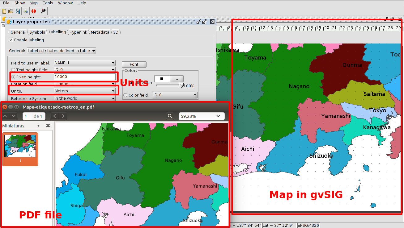
The cause is because we are working in pixels instead of length unities (meters, kilometers…). The pixel is an immaterial concept that doesn’t have a concrete measurement, it is a cell measurement unity, they are “screen” unities.

For this reason, when we have the labels or symbols in a layout in pixel unities, we can see them correctly at the screen, but when we see them at the “paper space” we don’t have pixel unities, so it can change depending on the zoom/scale that we have at the screen.

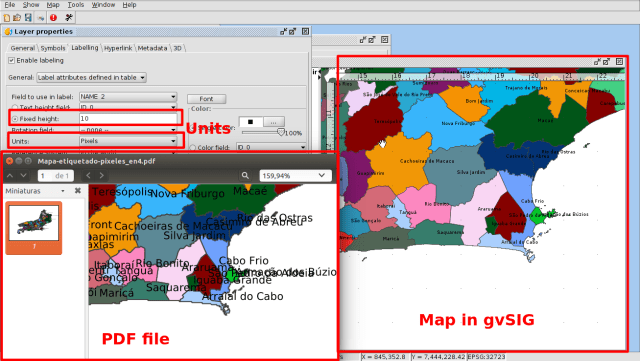
PDF file created from a layout, with pixel unities

We can solve it selecting length units, like meters. At this way, we will have at the paper or PDF file the same visualization than in the screen. If symbols or labels are not overlapped at the screen, they won’t be overlapped at the PDF file or at the paper, we will see them at the same way.

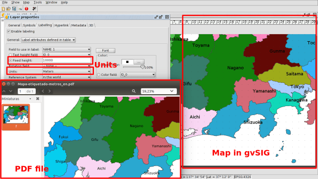
PDF file created from a layout, with meter unities

Depending on the scale that we are using we will have to select a different value. For example, if we are working with a complete country in a view, if we want to label the different regions we would be able to write 10.000, 20.000… meters for example, and if we are working in a local area, with municipality names, it can be 500, 1000… meter (of course it will depend on the size of our country).

It will be the same than the point (for example a hospital or a tree) or line (motorway, national road…) symbols, where we can work with a few meters. For example the size of a tree symbol size would be able to be about 4-5 meters.

To get the best results we will have to check it with different values until we visualize what we want at the layout.

In addition, at the labeling, apart from playing with the units as we have told, we also can use the advanced labeling (selecting “User defined labels” option at the first pull-down menu of Labeling tab at layer properties), where we can customize our labels (labeling each label in a different way, adding fixed text and a text from the attribute table…) as well as delete the repeated labels, avoid their overlap (indicating the priority of their location)…

We also will be able to select the interval of scale where the symbols or labels will be shown. For that we will install the extension about Create labels or Create legends by scale.

We hope that this information is useful for you!

Posted in english, gvSIG Desktop, training | Tagged , , , | Leave a comment