
 We publish the second module (of seven) of the free ‘GIS applied to archaeology’ course, where you will learn to create geographic information through the editing tools offered by the open source software called ‘gvSIG Desktop’.
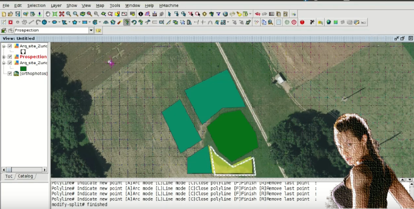
We will start by creating a new layer of information that will represent our prospection areas. In that layer we will create new geometries and we will fill its attribute table in with alphanumeric information.
We will also see how to add information to an existing layer using the ‘table join’ tool.
To follow these exercises you will start with the project created in the first module of the course, so if you have not done already we recommend you start there.
The data to follow the course can be downloaded compressed in a .zip file on this link.
Remember that for doubts about software use, carrying out the exercises, and problems that you find when carrying out the course, you can use the gvSIG users mailing list.
Module 2: Creating geographic information
Previous modules:
Module 1: Preparation of an archaeological project


Pingback: Digitalizing prospection areas. GIS applied to Archeology — gvSIG blog – Museistícate
Hello professor,
My name is sreang em, Cambodian archaeologist. I work in National Authority for Sambor Prei kuk, Ministry of culture and Fine Arts, Cambodia.
My experience in archaeological survey, excavation, and Land management but not good, so I want to upgrade and extend.
Hello sreang em, with this course you will be able to learn to manage this GIS and free of charge. It will be useful for you. We hope that you enjoy the course.
the program works great, thanks teacher
Nice!
Pingback: Analysis of prospection results: Vector geoprocessing. GIS applied to Archeology | gvSIG blog
Great and helpful lessons professor
Thank you
Pingback: Working with historical maps: Georeferencing images. GIS applied to archaeology | gvSIG blog
Pingback: Territorial analysis of archaeological sites: Raster geoprocessing and Digital Elevation Models. GIS applied to Archeology | gvSIG blog
Pingback: Hydrological analysis to locate archaeological material or sites. GIS applied to Archeology | gvSIG blog
Pingback: Graphical output of an archaeological project: Layouts. GIS applied to Archeology | gvSIG blog
Pingback: Free course about Geographic Information Systems applied to archaeology: Certification and links to the complete course | gvSIG blog