In the last gvSIG Conferences we talked about a series of geoprocess created for criminology developed with Universidad Jaume I (UJI). You can see the video here (in spanish, if you have any question you can write directly to us and we will help you). This geoprocess can be used in different fields, not only in criminology.
The first geoprocess that we are going to present is the Ring Map. The objective of this geoprocess is to make easy to visualize info that is inside the layer. For example, it will show info in multiple fields in a single map.
In this example, we are going to see a layer with the population on each block for different range of ages. The result of the ring map will be like in the image. Now with this graph, with a quick look, we can analyse quickly how the population is distributed in each block and in different age ranges.
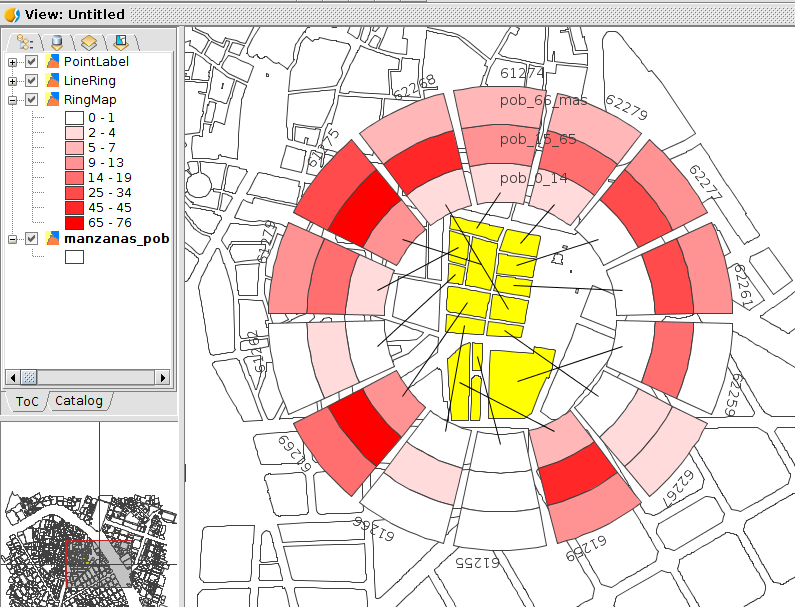
This geoprocess generate a series of rings and sectors. Each ring is a reference for the same field, and each sector is for the same geometry, that is pointed with an arrow. It creates three new layers with the rings, labels and arrows. Each of them can be modified as a normal shapefile. It creates an automatic legend that can also be modified as we need them.
The parameters that we need to execute this geoprocess is, at least one layer, (with any type of geometry) that it has a field with unique values for each geometry. It needed a opened table. If you are going to use layers, be sure that you open previously the attributes table, if not, this table will not appear as an option. If it doesn’t have an unique field, you can create it using the Field Calculator. This option has been created becouse it is posible to create diferent representations (differents table) to show them over the same vectorial layer.

The fields should be written in the order that we want them to appear. Also, we have multiple options for change the visualization of the rings. We can change sectors, gaps, size, labels..
 This is a similar result from the initial image.

As always, you can see more information about this process pressing the help button.
You can test the Ring Map geoprocess at the new distribution candidate to final version. Just go to Tools -> Addons Manager and Search for “Geoprocess: Ring Map”.
If you find any error we encourage you to write about it at the users mailing list. It will help us to fix them.


Pingback: Towards @gvSIG 2.5: New geoprocess, Ring #map – GeoNe.ws
Pingback: Towards gvSIG 2.5: New geoprocess, Grid by point density | gvSIG blog
Pingback: Towards gvSIG 2.5: New geoprocess, Aoristic Clock | gvSIG blog
Pingback: Towards gvSIG 2.5: New geoprocess, Aoristic Clock by grid | gvSIG blog
Pingback: gvSIG 2.5 RC2 is now available to download | gvSIG blog