How to extract the coordinates of a parcel in gvSIG

We can get the coordinates of the vertexes of one or more parcels in an easy way in gvSIG through scripting.

We can do it on SHP files as well as DWG, DGN or DXF.

Script_vertex

For that we will have to create a new script in gvSIG, from the Tools->Scripting->Scripting Composer menu.

Once it is created, naming it as we want, we copy this source code on it:

from gvsig import *
from commonsdialog import *

def main(*args):
    """Read wkt"""
    sel = currentLayer().getSelection()
    pfile = str(saveFileDialog("Select output text file")[0])
    f = open(pfile,'w')
    for s in sel:
        f.write("\n\n================\n\n")
        f.write("\n"+str(s.getValues())+"\n\n")
        g = str(s.geometry().convertToWKT())
        f.write(g)
    f.close()
    print pfile

After that we save the script.

Now, on the gvSIG View, we select the parcel/s that we want, and we open the Scripting Launcher (Tools->Scripting->Scripting Launcher menu).

We press with double-click on the Script that we had created, and a new window will be opened, where we can select the output file that will contain the coordinates, and the folder (it is recommendable to name it as a .txt in order to be recognized by the text editor easily).

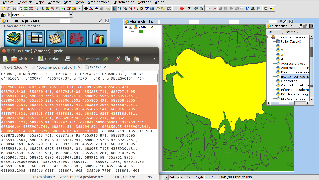
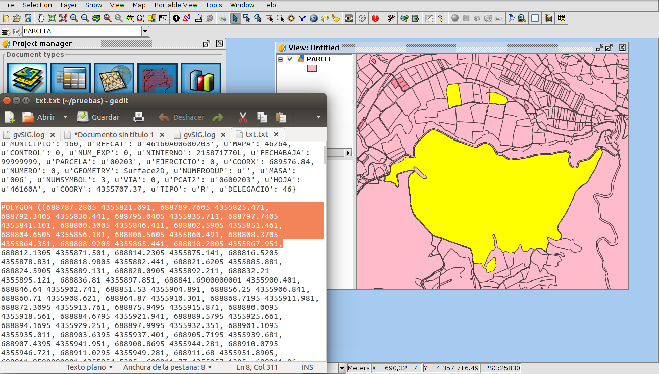
If we open that file later, we will be able to see the coordinates of the different vertexes of the parcel, and if it was a polyline we can see the coordinates of each line that forms it.

If we had selected several elements, they will be visualized separately at the same file.

At the first line the values of the different fields of that register will be shown. It will allow us to know which element the information is referring to, in case we had selected several parcels.

We hope that this tool is useful for you!

Posted in CAD, english, gvSIG Desktop | Tagged | 1 Comment

Cómo extraer las coordenadas de los vértices de una parcela en gvSIG

En gvSIG podemos extraer de una forma sencilla las coordenadas de los vértices que conforman una o varias parcelas mediante scripting.

Podremos hacerlo tanto para ficheros de tipo SHP como DWG, DGN o DXF.

Script_vertices

Para ello tendremos que crear un nuevo script en gvSIG, desde el menú Herramientas->Scripting->Editor de Scripts (este menú se llama “Scripting Composer” hasta la versión 2.2).

Una vez creado, con el nombre que deseemos, copiamos el siguiente código en él:

from gvsig import *
from commonsdialog import *

def main(*args):
    """Read wkt"""
    sel = currentLayer().getSelection()
    pfile = str(saveFileDialog("Seleccionar fichero texto de salida")[0])
    f = open(pfile,'w')
    for s in sel:
        f.write("\n\n================\n\n")
        f.write("\n"+str(s.getValues())+"\n\n")
        g = str(s.geometry().convertToWKT())
        f.write(g)
    f.close()
    print pfile

Después guardamos dicho script.

Ahora ya sobre la Vista de gvSIG, seleccionamos la/s parcela/s que deseemos, y abrimos el lanzador de scripts (menú Herramientas->Scripting->Lanzador de Scripts; este menú se llamaba “Scripting Launcher” hasta la versión 2.2).

Con doble-click sobre el Script que habíamos creado se abrirá una ventana donde podremos seleccionar el nombre del fichero de salida con las coordenadas, y la carpeta donde guardarlo (recomendable nombrarlo como .txt para que lo reconozca directamente después el editor de texto).

Si abrimos después dicho fichero podremos ver los pares de coordenadas de los distintos vértices del polígono, y si era una polilínea veremos las coordenadas de los vértices inicio y fin de cada línea que la compone.

Si habíamos seleccionado varios elementos se visualizarán por separado en el mismo fichero.

En la primera línea también se mostrarán los valores de los distintos campos del registro en cuestión, lo que nos permitirá, en caso de que hubiéramos seleccionado varias parcelas, saber a cuál de ellas pertenece esa información.

¡Esperamos que os sea útil esta herramienta!

Posted in CAD, gvSIG Desktop, spanish | 7 Comments

gvSIG Festival: First virtual gvSIG Conference is coming!

festival portada v03

From May 23rd to 27th there’s an event that you can’t miss: the first gvSIG Festival. In this case it doesn’t matter where you live or even what language you speak since you will be able to attend (virtually) more than twenty webinars in different languages

There is no doubt that gvSIG is increasingly worldwide project: if it has a strong implementation in Portuguese and Spanish speaking countries, it’s currently well-known in more an more countries, in every continent, in every language.

An idea that we were thinking about during the last months was to show varied experiences and in different languages, removing the limitations of the events in an only place. And this take us to this first gvSIG Festival.

From some weeks ago we have a webinar service at the gvSIG Association, so we have decided to organize a first virtual conference.

This time we have decided not to open call for presentations but inviting some colleagues of the gvSIG Community to tell us about some experiences related to the gvSIG technology (gvSIG Desktop, Online, Roads…). For sure at the next edition (we are sure that it will be successful!) we will open a period for sending proposals to convert it in a more global and open event.

We think that the program meets the objective to show the variety of uses and users that take part of the gvSIG Community.

There will be presentations in English, Spanish, French, Portuguese, Turkish and Russian.

We will count with speakers and works developed in Argentina, Brazil, Colombia, Costa Rica, Spain, United States of America, France, India, Italy, Kenya, Mexico, Paraguay, Peru, Russia, Somaliland, Turkey y Uruguay.

They will speak about how the gvSIG technology can be applied in different themes like mental health, civil protection, cooperation, historic studies, roads management, acoustic analysis, hydrology, tourism, urban analysis…, in conclusion about how gvSIG can help to meet the needs of the society and improve the life of the inhabitants of the Earth.

Working from a variety of countries, under the same project that is built on the collaboration, solidarity and shared knowledge bases.

You can consult the complete program in: www.gvsig.com/festival

Notes:

  • We will publish the information about how to register at the webinars soon. 
  • The webinar platform allows to connect  to the webinars from any operating system.
  • Attendees will be able to ask questions that will be answered during the webinar.


Posted in community, english, events, press office, training | Leave a comment

gvSIG Festival: ¡Llegan las primeras jornadas virtuales de gvSIG!

festival portada v03

Del 23 al 27 de mayo hay una cita que no os podéis perder: el primer gvSIG Festival. En este caso no importa dónde vivas e incluso que idioma hables, pues durante una semana vas a poder asistir (virtualmente) a más de una veintena de webinars en distintos idiomas.

No cabe duda que gvSIG es cada vez un proyecto más internacional: si en su primera fase de expansión tuvo una fuerte implantación en países de habla hispana y portuguesa, actualmente se está dando a conocer con fuerza en cada vez más países, en todos los continentes, en todos los idiomas.

Una idea que llevaba tiempo rondándonos por la cabeza era poder mostrar experiencias diversas y en diversos idiomas, eliminando las limitaciones que conlleva realizar un evento en un determinado lugar. Y eso nos lleva a este primer gvSIG Festival.

Desde hace unas semanas disponemos de un servicio de webinar en la Asociación gvSIG, con lo que ya sólo nos quedaba lanzarnos a la aventura de organizar unas primeras jornadas virtuales.

Nos hemos decidido a no hacer un llamado abierto a ponencias e invitar a algunos compañeros y compañeras de la Comunidad gvSIG a contarnos algunas experiencias relacionadas con la tecnología gvSIG (ya sea gvSIG Desktop, Online, Roads…). Eso sí, en la segunda edición (¡estamos seguros de que esto será un éxito!) abriremos convocatoria para convertir esta iniciativa en un evento todavía más global y abierto.

El programa creemos que cumple perfectamente con el objetivo de mostrar la variedad de usos y usuarios que forman parte de la Comunidad gvSIG.

Tendremos ponencias en Español, Francés, Inglés, Portugués, Ruso y Turco.

Contaremos con ponentes y trabajos desarrollados en Argentina, Brasil, Colombia, Costa Rica, España, Estados Unidos, Francia, India, Italia, Kenia, México, Paraguay, Perú, Rusia, Somaliland, Turquía y Uruguay.

Nos hablarán de cómo la tecnología gvSIG se puede aplicar a temas tan variopintos como la salud mental, protección civil, cooperación, estudios históricos, gestión de carreteras, análisis acústico, hidrología, turismo, análisis urbanos,…en definitiva, de como gvSIG puede ayudar a responder a las necesidades de la sociedad y a mejorar la vida de los habitantes de este planeta.

Trabajando desde una gran variedad de países, bajo un mismo proyecto que se construye sobre las bases de la colaboración, la solidaridad y el conocimiento compartido.

Podéis consultar el programa completo en: www.gvsig.com/festival

Notas:

– En breve publicaremos la información para inscribirse a los webinars.

– La plataforma de webinar permite conectarse desde cualquier sistema operativo.

– Los asistentes podrán realizar preguntas que serán contestadas durante el webinar.


Posted in community, events, press office, spanish | Tagged | 3 Comments

gvSIG Festival: Keep Calm More Info Coming Soon

gvsig_festival portada_PRE

Posted in community, english, events, press office | Leave a comment

gvSIG 2.3: Working on new improvements

gvSIG_improvement

In 2015 we established a rule for releasing two gvSIG versions per year, that we achieved at the gvSIG 2.1 and gvSIG 2.2 versions. In 2016 the dynamics would be to release another two versions, gvSIG 2.3 and gvSIG 2.4, the first one before Summer and the other one at the end of this year. However we decided to broke the rules and we announced that we were going to release three gvSIG versions in 2016. Therefore we started the gvSIG 2.3 stabilization period in December in the last year, and in February we released the first RC version (release candidate to the final one). We planned to dedicate a few more resources to fix important bugs and release the final gvSIG 2.3 version.

However there have been good news that will make us follow the rules. That means, that we are going to delay the gvSIG 2.3 releasing some months, and only two versions are released instead three versions in 2016.

Good news? Yes, we aren’t going to provide resources to stabilize gvSIG because a large amounts of new functionalities have been contracted, that will allow to increase the quality of gvSIG (even more) and convert it in a more powerful GIS. These new developments have a deadline, so we have decided to dedicate all our resources to them. The secondary effect has been the delay of that version, that in the other side was changing the publishing dynamics.

And what are we working on? We are working in a large number of improvements. Some of them will be included at the next gvSIG 2.3 version. Here you have a short list with the main tasks:

  • External map providers like Google Maps or Bing Maps access.
  • Google Street View access.
  • LiDAR data access and management (in 2D Views as well as in 3D ones).
  • Vector data loading on 3D Views.
  • Extrusion in 3D Views.
  • Complete support of the projections database in 3D Views (currently it only supports EPSG:4326), so raster reprojection from 2D to 3D.
  • Geoprocessing for building layers detection and creation, and automatic height detection from LiDAR data.
  • LRS tools support for PostGIS database.
  • CSV files importer similar to the Libreoffice one.
  • New 3D functionalities (animation, temporary data…).
  • Raster architecture refactoring (note: If you are going to make raster developments we recommend you to contact us so that your work can be integrated with the changes to be made).
  • Projections support: finishing the transition started GDAL use in projections.

Now you sure will wait the next version enthusiastically.  

🙂 🙂

Posted in development, english, gvSIG Desktop | Leave a comment

EMT Valencia: ejemplo de geoportal de transporte público con software libre

Uno de los primeros proyectos que realizamos en la Asociación gvSIG fue la puesta en marcha del geoportal de EMT, la empresa municipal de transporte de Valencia. Hace ya más de un lustro desde que está en marcha y sigue siendo la web de referencia para consultar el cómo ir de un sitio a otro de la ciudad utilizando los distintos medios de transporte disponibles: metro, autobús, bicicleta, Valenbisi (servicio público de alquiler de bicicletas) o a pie.

Todo los desarrollos se realizaron sin gastar un euro en licencias, utilizando exclusivamente software libre y pese al tiempo que ha pasado sigue siendo uno de los planificadores de rutas de transporte urbano más completos que uno puede encontrar. Un ejemplo más de porqué la Asociación gvSIG se ha convertido en un referente internacional en geomática libre.

Mediante este geoportal podemos calcular cualquier ruta, indicando los medios de transporte que queremos utilizar y nos informará de las distintas rutas posibles, permitiendo evaluar cada una de ellas y seleccionar la más adecuada para el usuario. Entre los detalles de ruta llega incluso a calcular el ahorro de emisiones de CO2 causantes del efecto invernadero (comparándolo con la cantidad de árboles que harían falta para ahorrar dicha cantidad de CO2 en un día) respecto a realizar el mismo recorrido con un coche privado.

Además de las herramientas relacionadas directamente con el cálculo de rutas, el usuario encuentra un buen número de utilidades: descubrir qué elementos de interés hay cerca de un punto, consultar las rutas y horarios de cada línea de autobús, visualizar por categorías los puntos de interés, imprimir planos de ruta, etc.

A continuación tres vídeos que muestran en funcionamiento la aplicación…aunque lo mejor es que cuando vengáis a Valencia (por ejemplo, para las próximas Jornadas Internacionales de gvSIG) lo probéis y descubráis toda la utilidad de esta aplicación (http://www.emtvalencia.es/geoportal/)

Si esto es lo que hacíamos en nuestros inicios…imaginad qué podemos hacer ahora.

Si estás interesado en implantar soluciones de este tipo en tú organización, contacta con nosotros: info@gvsig.com . Además de contar con los mejores expertos en geomática libre estarás ayudando al mantenimiento y desarrollo de la tecnología gvSIG.

Posted in Business, geoportal, gvSIG Association, Projects, spanish | Tagged , , , , | 2 Comments

gvSIG 2.3: Trabajando en nuevas mejoras

gvSIG_improvement

En 2015 establecimos la norma de publicar dos versiones de gvSIG al año, que cumplimos con la salida de gvSIG 2.1 y gvSIG 2.2. En 2016 la dinámica sería publicar otras dos versiones, gvSIG 2.3 y gvSIG 2.4, una antes de verano y otra para finales de año. Sin embargo, decidimos saltarnos la norma y anunciar que sacaríamos tres versiones de gvSIG en 2016. Para ello comenzamos el período de estabilización de gvSIG 2.3 en diciembre del año pasado y en febrero publicamos la primera RC (candidata a final). La previsión era dedicar unos pocos recursos más a corregir los bugs (errores) importantes destacados y ya publicar la versión final de gvSIG 2.3.

Sin embargo ha habido una buena noticia que va a provocar que nos saltemos la excepción y sigamos la norma. Es decir, que atrasemos la publicación de gvSIG 2.3 unos meses y, finalmente, en 2016 vean la luz dos versiones de gvSIG en lugar de tres.

¿Buena noticia? Sí, porque el motivo de no dedicar recursos a finalizar la estabilización de gvSIG ha sido la contratación de una gran cantidad de nuevas funcionalidades que van a permitir dar un salto de calidad (otro más) a gvSIG y convertirlo en un SIG todavía más potente. Esos nuevos desarrollos además tienen fecha de entrega, por lo que hemos tomado la decisión de dedicar todos nuestros esfuerzos a ello y como efecto secundario retrasar la salida de una versión que, por otro lado, se salía de la dinámica de publicación de versiones establecida.

¿Y en qué estamos trabajando? Pues en un buen número de mejoras, algunas de las cuales verán la luz en la próxima gvSIG 2.3. Aquí va un breve listado de las principales tareas:

  • Acceso a proveedores de mapas externos como Google Maps y Bing Maps.
  • Acceso a Google Street View.
  • Acceso y manejo de datos LiDAR (tanto en Vistas 2D como en Vistas 3D).
  • Carga de datos vectoriales en Vistas 3D.
  • Extrusión en Vistas 3D.
  • Soporte completo de la base de datos de proyecciones en Vistas 3D (actualmente sólo soporta EPSG:4326) y, por tanto, reproyección ráster de 2D a 3D.
  • Geoprocesos para detección y generación de capas de edificaciones, y detección automática de alturas a partir de datos LiDAR.
  • Soporte de las herramientas de LRS/Segmentación Dinámica para bases de datos PostGIS.
  • Importador de ficheros csv al estilo LibreOffice.
  • Nuevas funcionalidades 3D (animaciones, datos temporales,…)
  • Refactoring de la arquitectura ráster de gvSIG. (nota: Si vas a hacer desarrollos ráster, te recomendamos que te pongas en contacto con nosotros, para que tu trabajo se pueda integrar con los cambios que se van a realizar).
  • Soporte a proyecciones: finalizar la transición iniciada para el uso de GDAL en proyecciones.

Ahora seguro que todavía esperareis con más ganas la salida de la próxima versión de gvSIG.

🙂 🙂

Posted in development, gvSIG Desktop, spanish | Tagged , , , , , | 2 Comments

Assessing the quality of urban layouts (II)

As we announced in a previous post, we are describing the basis of the methodology developed by the gvSIG Association and New York University (NYU) within the project “Monitoring Global Urban Expansion”, for assessing the quality of urban layouts.

Metrics

The objective of the methodology is to measure the following features:

  • Land Use Areas and Shares
  • Proportion of Street Space
  • Street Widhts
  • Block Size
  • Intersection Density
  • Walkability
  • Plot Dimensions
  • Access to Arterial Roads

All these features were obtained from vector cartography through geoprocessing algorithms. The first step therefore was creating the necessary cartography. For this we used an Open Source mapping software from the OpenStreetMap project called JOSM. The main data sources used were Bing and MapBox satellite imagery.

Sampling

Since mapping the entire cities would not be affordable we considered using sampling methodologies: a quasi-random sequence called Halton, which has the advantage of providing points with a very good spatial distribution but still they are random, which is very important from the statistical point of view.

Selection_608Around each point in the sequence within the study area we drew a circle with an area of 10 hectares called “locale” in which we focused the analysis. It is woth stressing that each locales was given a unique identifier with the aim that they can be used in future studies.

Depending on the size of the study area different locale densities were used: for areas smaller than 25 Km2 we generated 4 locales per Km2 while for areas larger than 25 Km2 we generated 1 locale per Km2.

Land Use classification

Before the digitization we established a classification of land uses including the following categories:

  1. Open Space. It mainly refers to any unbuilt areas, particularly:
    – Open countryside
    – Forests
    – Crop fields
    – Parks
    – Water bodies
  2. Non-Residential. It includes built-up areas that are not for residential use such as:
    – Industrial parks
    – Railway stations and tracks
    – Bus terminals
    – Airports
    – Schools and universities
    – Shopping centers
  3. Residential. For residential areas we established 4 subcategories depending on the stage in their evolution and particularly considering the following main factors: homogeneity of structures, regularity of the street network and quality of public services.
    1. Atomistic: areas that were not laid out or subdivided in advance of the residential development.
    2. Informal Land Subdivision: subdivided areas that lack of some public services, particularly paved streets and sidewalks.
    3. Formal Land Subdivision: similar to the former category but with high level of infrastructure.
    4. Housing Project: areas where structures are homogeneous because they were built off the same plan. It may include from apartment towers to suburban tract housing.

Digitization

For each locale the following elements were digitized:

  • Locale Boundary. It’s the circle itself except when an overlap between two circles take place, in which case one of the circles is clipped. From this element we get the total area of the locale.
  • Blocks. Contains the boundaries of all the blocks falling within the locale, tagged according to their land use category.Selection_626
  • Plot Measurements. In those blocks in which the plot size was regular and plot boundaries were easy to identify some measurements on plot depth and width were taken.Selection_616
  • Road Medians. We digitized the road medians around all the blocks intersecting or completely included in the locale.Selection_630

Sample representativeness

In order to guarantee the representativeness of the sample we proceed as following: we digitized an initial set of 40 locales; then we calculated all the metrics, the average values and, through a statistical test, its degree of confidence. Until a high degree of confidence was reached we kept digitizing locales.

Digitization of Arterial Roads

Simultaneously to the digitization of locales we carried out the digitization of all the Arterial Roads of each city, which are those roads that are more than 18 meters wide and, at the same time, are connected to other roads more than 18 meters wide.Selection_628

Metrics calculation

Once all the necessary elements were digitized we proceed to the calculation of the metrics using two Python scripts, one for the locale metrics and a second one for the Arterial Roads metrics.

Posted in english, gvSIG Desktop, technical collaborations | Tagged , | 2 Comments

gvSIG en los papeles de Panamá

Después de 12 años de vida de gvSIG, aún me sigo sorprendiendo con las continuas referencias que me llegan de donde se está utilizando, que si en este ayuntamiento o aquel departamento universitario. En estos años son multitud de administraciones (supranacionales, nacionales, autonómicas y locales), universidades y empresas de varios países, de las que me siguen llegando noticias tanto de la utilización de gvSIG a nivel de usuario, como de la realización de nuevos desarrollos que evolucionan la herramienta; e incluso, lo bien que ha venido en ciertos casos la ‘amenaza’ gvSIG para negociar a la baja ciertos contratos relacionados con la adquisición de software cerrado.

Y durante todo esto tiempo, algo que ¿sigue sorprendiendo? Es la ausencia generalizada de llamadas que el proyecto recibe, o mejor dicho, quien lo gestiona, que no es otra que la Asociación gvSIG, para buscar colaboraciones, oportunidades o simplemente, recibir apoyos. Si por algo se ha caracterizado el planteamiento de: “que bien me ha venido gvSIG, voy a ver como puedo colaborar, sea económicamente, sea aportando mis desarrollos” ha sido por su ausencia generalizada. ¿Motivos? Pues no sé, quizá esté ligado a rasgos de la idiosincrasia latina, que en muchos aspectos es más individualista que otras. Una idiosincrasia donde un pícaro es un listo y no un estafador, pero bueno, esto sería otro debate.

Por supuesto que en la Asociación, según me cuentan, reciben peticiones; pero sinceramente, creo que son mínimos en relación con el impacto que realmente tiene gvSIG, y más observando la evolución de una Asociación que en torno a una marca de éxito, no sólo sigue mejorando y evolucionando el gvSIG Desktop, sino que está generando nuevos productos libres y especializados, como gvSIG Online (Infraestructuras de Datos Espaciales libres) o gvSIG Roads para la gestión integral de carreteras.

Sé que además, en la Asociación gvSIG tienen nuevos proyectos en cartera esperando a recibir un mínimo impulso que les permita convertirlos en realidad. En una realidad al servicio de todos.

Bueno, llegado a este punto (gracias a quién haya llegado) se preguntarán, ¿Pero que tiene que ver el rollo que nos está contando este tío con lo de los papeles de Panamá? Pues parece ser que nada, este ha sido el típico y antiguo artificio de poner un titular atractivo, pero que nada tiene que ver con lo que se cuenta. Pedir disculpas a todos los que se hayan sentido molestos o engañados por la utilización de este recurso.

Aunque ahora que pienso. ¿No tiene nada que ver? Bueno una cosa que si que tengo clara es que la filosofía de gvSIG, el modelo de negocio que propone basado en valores como la Solidaridad y la Colaboración; la política de alianzas que trabaja, buscando fortalecer y colaborar con el tejido industrial de allá donde se desarrollen los proyectos; en definitiva, esta nueva ética de trabajo a la que modestamente intenta contribuir, de buen seguro que es diametralmente opuesta con esa vergüenza de los papeles de Panamá.

gvSIG, y el software libre en general, apuesta por la libertad del conocimiento y la transparencia de la información que es lo que le falta a esos oscuros paraísos fiscales cuya intención es ocultar vergonzosas riquezas no declaradas.

@GabrielCarrionR


Posted in gvSIG Desktop, opinion, spanish | 10 Comments