
The new version of gvSIG Desktop, the open source GIS, is now available to download.
This new version is an important step at the gvSIG evolution, because of its multiple improvements and novelties in a functional level as well as in an architecture one.
You can download gvSIG 2.3 from here:
http://www.gvsig.com/en/products/gvsig-desktop/downloads
A here you have a list of novelties:
| Distribution for Windows 64 bits.
This new distribution has been added to the existing ones: Windows 32 bits and Linux 32 and 64 bits, as installable and portable versions. |
 |
 |
Portable distribution for Mac OS X
We release this official distribution for users of this operating system for the first time. More information: https://blog.gvsig.org/2016/09/14/towards-gvsig-2-3-portable-distribution-for-mac-os-x/ |
|
GDAL: projections and raster access library From this version we use GDAL as projections and raster information access library. One of the consequences of this change is the access to lots of new formats (MID/MIF de Mapinfo, Geojson, CityGML, etc.) through GDAL. More information: in: https://blog.gvsig.org/2016/03/08/on-the-road-to-gvsig-2-3-new-available-formats-ogr-gdal/ |
 |
|
New installer with 64 bits support |
New geometry library
More efficient support for multigeometries |
|
Java 8 support |
Automatic creator of gvSIG Debian de gvSIG |
|
PRJ format (projections) reading and writing It is a file that is attached to an information layer (shapefile, raster…) that has information about its coordinates reference system. More information: https://blog.gvsig.org/2016/03/08/on-the-road-to-gvsig-2-3-read-and-write-prj-files-projections/ |
 |
 |
R: Statistics in gvSIG
R statistics library support through Renjin or integrating R directly. More information: https://blog.gvsig.org/2016/03/17/running-r-source-code-from-gvsig-2-3-through-renjin/ and here: https://blog.gvsig.org/2016/09/29/towards-gvsig-2-3-r-extension |
|
Lots of improvements in scripting There are a lot of improvements in the Scripting module in gvSIG 2.3. Now it is very easy to develop in gvSIG More information in these links (posts in Spanish will be translated soon): https://blog.gvsig.org/2016/09/06/towards-gvsig-2-3-new-integration-at-the-scripting-libraries/ https://blog.gvsig.org/2016/08/31/camino-a-gvsig-2-3-compatibilidad-y-cambios-en-scripts/ https://blog.gvsig.org/2016/09/01/camino-a-gvsig-2-3-ejemplo-de-script-con-la-nueva-implementacion/ https://blog.gvsig.org/2016/09/05/camino-a-gvsig-2-3-insertar-nuevos-geoprocesos-mediante-scripting/ https://blog.gvsig.org/2016/09/20/camino-a-gvsig-2-3-autoarranque-de-scripts-al-iniciar-gvsig/ |
 |
 |
Dynamic segmentation/Linear Reference System (LRS)
Tool to work with this spatial reference method in which the positions of the elements are referred to measurements along a linear element. This ability involves a set of tools that let define routes, calibrate each route from the milestones, edit the M coordinate of an element, depict it and generate new layers that support dynamic segmentation. More information in these links: https://blog.gvsig.org/2015/11/24/on-the-road-to-gvsig-2-3-dynamic-segmentation-lrs-i/ https://blog.gvsig.org/2016/02/18/on-the-road-to-gvsig-2-3-dynamic-segmentation-ii/ https://blog.gvsig.org/2016/02/22/on-the-road-to-gvsig-2-3-dynamic-segmentation-iii/ https://blog.gvsig.org/2016/02/26/on-the-road-to-gvsig-2-3-dynamic-segmentation-iv/ https://blog.gvsig.org/2016/02/27/on-the-road-to-gvsig-2-3-dynamic-segmentation-v/ https://blog.gvsig.org/2016/02/27/on-the-road-to-gvsig-2-3-dynamic-segmentation-vi-and-final/ https://blog.gvsig.org/2016/02/29/on-the-road-to-gvsig-2-3-dynamic-segmentation-in-4-videos/ |
|
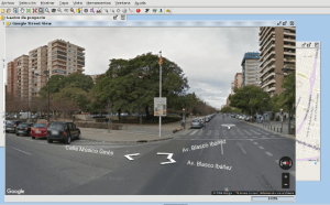
Google Maps, Bing Maps and Street View Possibility to add Google Maps and Bing Maps map services. Access to Google Street View. More information: https://blog.gvsig.org/2016/06/22/towards-gvsig-2-3-bing-maps-google-maps-and-google-street-view/ |
 |
 |
New OpenStreetMap servers Access to new OSM tile services, adding Stamen: Toner, Watercolor and Terrain.More information: https://blog.gvsig.org/2016/08/05/towards-gvsig-2-3-new-osm-openstreetmap-servers/ |
| LiDAR data reading and writing
LiDAR data support in .LAS format More information: https://blog.gvsig.org/2016/06/20/towards-gvsig-2-3-lidar-data/ |
 |
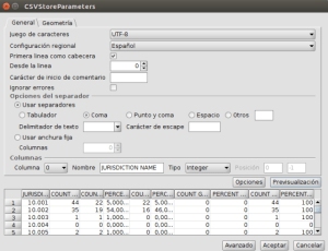 |
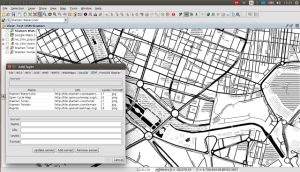
CSV (Wizard) importer
A wizard makes CSV loading easy, as table as well as layer More information: https://blog.gvsig.org/2016/08/08/towards-gvsig-2-3-csv-wizard-importer/ |
|
New editing tools Editing module continues improving with 3 new tools: change sense, curve to polyline, and parallel line. |
Distributions automatic generator
Plugin that allows to configure and create gvSIG distributions automatically for any operating system, customizing its working, OGC services, EPSG, appearance… |
|
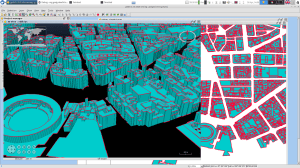
3D View improvements 2D to 3D views reprojection support Vector data support in 3D views 3D animations Extrusion More information: https://blog.gvsig.org/2016/06/20/towards-gvsig-2-3-reproject-2d-view-into-a-3d-view/ http://jgrasstechtips.blogspot.com.es/2016/06/extrusion-for-3d-vector-view-in-gvsig.html |
 |
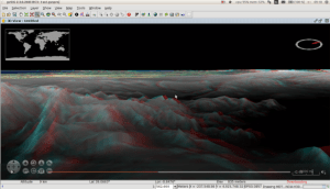 |
Anaglyphs
Possibility to view 3D Views in Anaglyph mode. More information: https://blog.gvsig.org/2016/09/09/towards-gvsig-2-3-anaglyph/ |
|
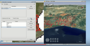
Animations Animations generator for 3D Views. More information: https://blog.gvsig.org/2016/09/06/towards-gvsig-2-3-3d-animations/ |
 |
 |
Cadastre browser (Spain) Users in Spain will be able to look for parcels by cadastral reference or location. More information: https://blog.gvsig.org/2016/06/02/camino-a-gvsig-2-3-buscador-de-referencias-catastrales-espana/ |
| Bookmarks
We will have a dataset catalogue with the cartography that we usually use, and they will be able to be loaded in our Views in a quick way. More information: https://blog.gvsig.org/2016/09/20/towards-gvsig-2-3-bookmarks/ |
 |
|
Automatic detection of heights Building detection and height comparative between layers from LiDAR data |
Online documentation
Online documentation available for users and developers |
And we have to add several small improvements besides error correction (bugs) that have been identified. Here you have some of these small improvements: update of all the languages (more than 30), tool to add layers to locator from the ToC, Groovy version updated for scripting, new INSPIRE symbol libraries, usability improvements…
If you have read all this post, you sure will want to download and test the new version. From today we start to work in gvSIG Desktop 2.4, and the releasing phase will start in December.
Finally, we want to tell you that your help, although it is small, can be very important to continue improving gvSIG. We encourage you to collaborate:
https://blog.gvsig.org/2016/05/12/contributing-to-gvsig-or-bidirectional-collaboration/


Pingback: gvSIG 2.3.1, a new gvSIG version with improvements oriented to cadastre | gvSIG blog
Pingback: Test and educational games in gvSIG | gvSIG blog